


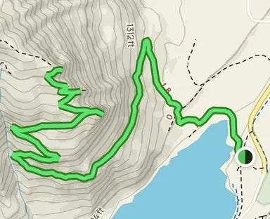
Length
5.3mi
Elevation gain
1,459ft
Route type
out & back
Head out on this 5.3-mile out-and-back trail near North Bend, Washington. Generally considered a moderately challenging route, it takes an average of 3 h 4 min to complete. This is a very popular area for hiking and running, so you'll likely encounter other people while exploring. The trail is open year-round and is beautiful to visit anytime. Dogs are welcome, but must be on a leash.
Take I-90 east and get off on Exit 32, 436th Avenue SE, just past the exits towards North Bend. Take a right off of the exit, heading south on 436th Ave SE which turns into Cedar Falls Road. Travel about three miles and follow the signs posted for Rattlesnake Lake. You will see several parking areas on both sides of the street. The park is a very popular location in the warmer months due to the lake. You may have to park on the edge of the road if the park is crowded.
Learn more about RATTLESNAKE LEDGE TRAIL
Description
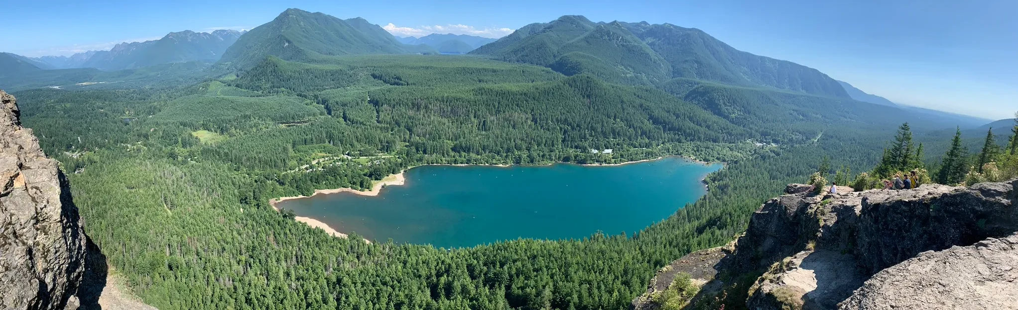
Located only a short 30 minute drive from downtown Bellevue and less than an hour away from Seattle, the climb up to the Rattlesnake Ledges is a very popular hiking trail in the summer months. Not only does this trail provide great panoramic views from atop Rattlesnake Ridge, but there is also a great park located below. Many people come to enjoy the lake in the warmer months. There are no motorboats or fishing allowed on the lake, making it an ideal destination for kayakers and swimmers.
The Rattlesnake Ledge Trail leaves from the parking lot on the north side of the lake. You’ll wind your way up the mountain and eventually meet up with the Rattlesnake Mountain Trail. First, you’ll come to the lower ledge. Here, you’ll have fantastic views of Mount Si and Mount Washington. Shortly after, you’ll come to the Middle Ledge and then the Upper Ledge. Although this hike features relatively less elevation gain than some of Washington’s other iconic climbs, the journey to the top of the Rattlesnake Ledges has all the great views you could hope for.
At the end of this route, you can choose to continue along the ridge of Rattlesnake Mountain for a full-day hike. Visitors looking to explore the park’s larger trail network can also find several connecting trails within the Rattlesnake Ridge parking area. You can find the Snoqualmie Valley Trail when leaving the parking area. This is a great trail if you’re looking for an easy hike or bike ride. The trail starts south of Rattlesnake Lake and continues up to Duval, over 35 miles of converted railroad to trail.
Waypoints
- Rattlesnake Lake
At the far edge of the lake you should be able to spot the Rattlesnake Ridge trailhead marker. You will cross over a compacted dirt access road and see a single portable restroom near the trail entrance.
47.43503,-121.76912 - Rattlesnake Ridge Trailhead Marker
This is the official start to the Rattlesnake Ridge Trail. From here you will be greeted by a gentle uphill climb.
47.43587,-121.772033 - Access Trail Road
You will come to a crossroad in the trail. To your left and right will be an old access road. The road does not appear to have been maintained for quite some time. Fallen trees will block your path, continue up the dirt path.
47.4362739,-121.77301884 - Viewpoint 1
This is one of many view points along the trail. Some of the viewpoints may require you to take a short detour off the trail to get a better view. Looking out over the edge you can see the lake below as well as the mountain range to the southeast.
47.4330226,-121.77997115 - Clearing Along the Trail
This is another vantage point along the trail. Now that you are moving further into the forest on your way to the peak, your views of the lake are limited. On clear days though you will always be able to catch glimpses of the mountains across the way.
47.4342999,-121.78246026 - Wooden Bridge
Here you will cross a short wooden bridge over a ravine. There are no water features on the trail unless you are hiking in heavy rain and crossing over the runoff. On your climb up through the switchbacks you will be able to hear a waterfall in the distance but it is not accessible from this trail.
47.4346483,-121.78314697 - Overlook Trail Marker
Congratulations! You are almost to the top. Continue on the trail to your right and you will arrive on a large rock ledge. From here you will have a great view of numerous mountains and reservoirs in the distance. Take a quick moment to enjoy the view and continue on the trail the left towards North Peak.
47.4361578,-121.77967078 - Rattlesnake Ledge Tier 1
Mount Si can be seen from the top of the ledge. Look to the North and the large mountain standing alone will be Mt. Si and Little Si. You can also see Mt. Washington. It is located to the east just across Rattlesnake Lake and to the right of I-90.
47.43609,-121.778649 - Rattlesnake Upper Ledge
47.43818,-121.78145
Tips
- There are restrooms by the lake as you enter the park
- No camping is available in the park
- An additional portable restroom is located in front of the trailhead marker
- No water is available within the park, you should pack your own water
- On Cedar Falls Rd, the road leading up to the park, there is a small shop where you can purchase food and drinks


